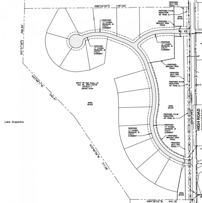
Flower Mound Planning & Zoning Commissioners on Monday agreed with the large audience gathered in the chamber and voted 6-0 to deny recommending approval to rezone the Serenity cluster residential development at next week’s Town Council meeting.
Although the physical components of Serenity raised concerns from residents, town staff and commissioners alike, the “spirit” of the development was a major underlying reason why not one person spoke in support of the project.
In addition, the town received a petition with signatures of more than 20-percent — it actually has 45 percent — of property owners within 200-feet opposed to a change, which triggers a required super-majority vote for approval.
The 28.92-acres cluster development site is located just north of Lake Grapevine on the western side of High Road within the Cross Timbers Conservation Development District (CTCDD) and is currently zoned Agricultural (A). Cluster development standards allow for lots smaller than the minimum two-acres required in Agricultural District (A) zoning.
“It’s a unique community consistent with the Cross Timbers Conservation Development District standards,” said Tracy LaPiene, project engineer with Ridinger Associates, during his presentation on behalf of absent local developer, Reginald Rembert.
The project has: 16 developable single-family lots on individual septic systems; 15-acres or 54-percent of open space, more than the required 50-percent; a 25-foot-wide landscape buffer; and, split-rail fence along High Road– all in accordance with the Town’s Urban Design standards.
However, it’s also a gated community with a six-foot wrought-iron fence surrounding the homes, 25-feet inside the “country-style” split-rail fence.
As Commissioner Al Picardi observed: “It’s a slight-of-hand development.”
In his overview of the project, Town Planner Chuck Russell said town staff has expressed concerns to Rembert regarding the project’s compliance with both the CTCDD and cluster development standards. He said staff has indicated to Rembert to demonstrate how the proposed development meets or exceeds the intent of the Town’s Master Plan and standards.
One concern continues to be how the proposed lot configuration inhibits scenic views from High Road, which is officially designated as a scenic drive.
To demonstrate the scenic ambiance along High Road, long-time resident and former P&Z Commissioner Jim Pearson played a video he had taken while driving down High Road.
“I see trees to my left and to my right,” he narrated. “I know there are lots of homes back there [on the east side of the road], but they’re not encroaching on my view.”
Another concern is whether the request demonstrates an appropriate transition to existing land uses– lot sizes, intervening roadways– which are mostly one-acre lots. The concept of a gated community surrounded by a six-foot-tall, wrought-iron security fence defeats the purpose of the split-rail fence providing a rural feel.
Planner Michael Coker, speaking for several neighboring residents, said Serenity in not compliant with the town’s Master Plan (MP) ordinance for cluster developments to: “preserve the character of the districts, the country atmosphere and natural environment.”
Residents said everyone who lives in the surrounding area knows each other, shares the trails and a gated community doesn’t reflect that mindset.
“The name of the road is actually ‘Hi’ Road, not ‘High’ Road,” said Victor Larson, a resident of more than 50-years. “It was named that, because everyone said ‘Hi’ as they rode past each other.”
The developer is requesting a 40-percent lot coverage, instead of the SF-30 standard of 35-percent, plus an increase in the minimum floor area per house from 2,100-square-feet to 2,800-square-feet in the Planned Development (PD) District.
Commissioner Laura Dillon said the purpose of cluster developments is to save land and views with open space, but Serenity’s, “placement of homes and the fencing is very dense.”
Russell was asked what the town’s recommended number of buildable lots on the specific property would be– considering topographical issues like slope percentages– and his answer was, “eight.”
“This [Serenity] does not fit the nature of that area,” said Commissioner Michael McCall. “And I’m against the slope infringement.”
As proposed, 5.1-acres of the project would be on land that slopes between 5- to 12-percent, with 9.3-acres on land with a slope of greater than 12-percent.
The loss of a rare Flower Mound meadow– which one speaker said the developer referred to as: “just a hay field” in the May required meeting with neighboring property owners– as well as the elimination of an existing stream were also listed as examples of the developer’s disregard of the area.
Commissioner Laile Neal said he feels that Serenity, “doesn’t satisfy the spirit” of the area.
Several residents also expressed concern about possible runoff issues from lawn-maintenance chemicals used on Serenity’s properties, as well as an increase in historic flooding problems on the eastern side of High Road. The increase in traffic on the very narrow road was also a concern.
Commissioner Heth Kendrick said that the old adage that, “fences make for good neighbors,” may also have the opposite result.
“You call it open space and fence it in,” he said. “It just makes it space.”
The Serenity development is set to be listed on the Town Council’s Nov. 20 meeting agenda.


